Strong Storms with Hail and Heavy Rain Possible Late Tuesday Night into Wednesday
Panama City, Florida – Strong thunderstorms are possible starting this evening and lasting into the overnight hours. Localized flooding and hail are possible with the strongest, most persistent storms.
A front is expected to stall across the Florida Panhandle Tuesday night and Wednesday. Disturbances high in the atmosphere will travel along the front, producing several clusters of thunderstorms in an increasingly warm, humid, and unstable air mass near the Gulf of Mexico. The unsettled weather is likely to continue through Thursday, before the front weakens and moves across the Florida Peninsula Friday.
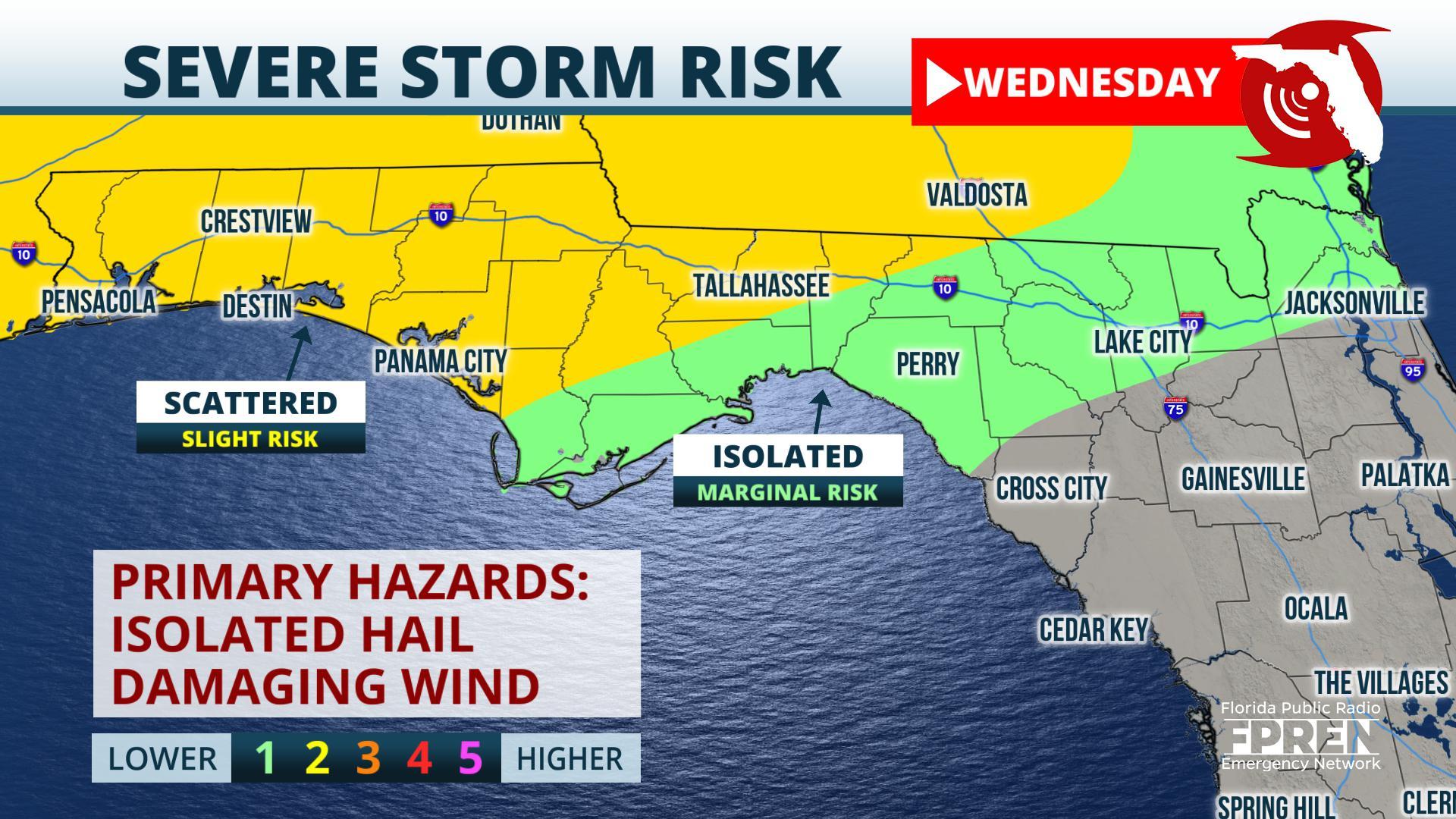
Showers and thunderstorms are expected to gradually increase in coverage and intensity Tuesday evening near the Interstate 10 corridor, particularly from the Lake City and Live Oak areas and areas west toward Tallahassee, Panama City, and Pensacola. Most of the high-resolution models forecast the thunderstorms to drift northward to within about 30 miles either side of the Florida/Georgia state line after midnight into Wednesday morning. Additional thunderstorms may develop during the heating of the day Wednesday afternoon, with the greatest risk of those storms forming west of Tallahassee to the Marianna, Crestview, Panama City, and Pensacola areas. The Storm Prediction Center has issued a “slight risk” (a level 2 out of a possible 5) of severe thunderstorms in these areas. Large hail is the greatest threat from the strongest thunderstorms overnight Tuesday into Wednesday morning.
Yet another round of thunderstorms is likely Wednesday afternoon and evening, but the timing and location is very uncertain, and will be highly dependent on how the first two rounds of thunderstorms evolve. This second round will be capable of damaging gusts and isolated tornadoes. Computer model simulations are forecasting a third round of thunderstorms on Thursday from Tallahassee eastward to Jacksonville, Gainesville, Ocala, and Lake City as a cold front moves eastward. These storms may also pose a threat of damaging winds and isolated tornadoes.
Rainfall amounts
The latest blend of computer model simulations are forecasting anywhere from an inch rain in the Jacksonville area to 2 to nearly 3 inches from Tallahassee westward through the Panhandle. These amounts reflect area-wide averages, but thunderstorms are almost sure to contribute heavier amounts in some areas. A “worst case” situation – rendered by an ensemble of computer models that create many possible scenarios to meteorologists — are indicating the potential for up to about 5 inches of rain in these areas. This scenario can become more probable where thunderstorms “train” or move over the same areas.
Flood potential
Rainfall totals over the past 30 days in the Florida Panhandle have been running slightly below average for areas south of Interstate 10. However, areas along and north of I-10 have had more rain than usual and may be more susceptible to flash flooding. There is also a chance the Escambia River, which was experiencing minor flooding near Century for a time in February, could return to minor flood stage again if heavy rain falls in its watershed.
Story by Meteorologist Ray Hawthorne of FPREN.


