Northwest Florida coast under Tropical Storm Warning
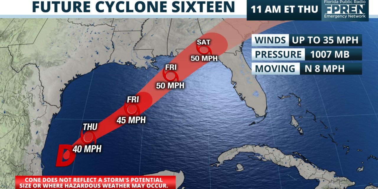
BULLETIN
Potential Tropical Cyclone Sixteen Advisory Number   1
NWS National Hurricane Center Miami FL       AL162019
1000 AM CDT Thu Oct 17 2019

...DISTURBANCE OVER THE SOUTHWESTERN GULF OF MEXICO EXPECTED TO
DEVELOP INTO A TROPICAL OR SUBTROPICAL STORM LATER TODAY OR
TONIGHT...
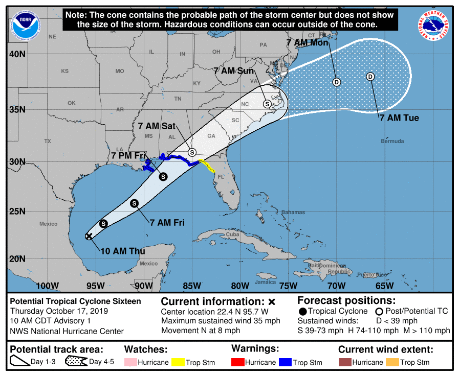
...TROPICAL STORM WARNINGS ISSUED FOR PORTIONS OF THE NORTHERN GULF
COAST...


SUMMARY OF 1000 AM CDT...1500 UTC...INFORMATION
-----------------------------------------------
LOCATION...22.4N 95.7W
ABOUT 140 MI...225 KM E OF TAMPICO MEXICO
ABOUT 620 MI...995 KM SW OF THE MOUTH OF THE MISSISSIPPI RIVER
MAXIMUM SUSTAINED WINDS...35 MPH...55 KM/H
PRESENT MOVEMENT...N OR 355 DEGREES AT 8 MPH...13 KM/H
MINIMUM CENTRAL PRESSURE...1007 MB...29.74 INCHES


WATCHES AND WARNINGS
--------------------
CHANGES WITH THIS ADVISORY:

A Tropical Storm Warning is in effect from the Mississippi/Alabama
border to the Ochlockonee River, Florida.

A Tropical Storm Warning is in effect from Grand Isle, Louisiana to
the Mouth of the Pearl River.

A Tropical Storm Watch is in effect east of the Ochlockonee River to
Yankeetown, Florida.

A Storm Surge Watch is in effect from Indian Pass, Florida, to
Clearwater, Florida.

SUMMARY OF WATCHES AND WARNINGS IN EFFECT:

A Tropical Storm Warning is in effect for...
* Mississippi/Alabama border to the Ochlockonee River, Florida
* Grand Isle, Louisiana to the Mouth of the Pearl River

A Tropical Storm Watch is in effect for...
* East of the Ochlockonee River to Yankeetown, Florida

A Storm Surge Watch is in effect for...
* Indian Pass to Clearwater, Florida

A Tropical Storm Warning means that tropical storm conditions are
expected somewhere within the warning area within 36 hours.

A Tropical Storm Watch means that tropical storm conditions are
possible within the watch area, generally within 48 hours.

A Storm Surge Watch means there is a possibility of life-
threatening inundation, from rising water moving inland from the
coastline, in the indicated locations during the next 48 hours.
For a depiction of areas at risk, please see the National Weather
Service Storm Surge Watch/Warning Graphic, available at
hurricanes.gov.

For storm information specific to your area, including possible
inland watches and warnings, please monitor products issued by your
local National Weather Service forecast office.


DISCUSSION AND OUTLOOK
----------------------
At 1000 AM CDT (1500 UTC), the disturbance was centered near
latitude 22.4 North, longitude 95.7 West.  The system is moving
toward the north near 8 mph (13 km/h).  A turn toward the northeast
is expected this afternoon or tonight, and a northeastward motion
at a faster forward speed is expected on Friday and Saturday.  On
the forecast track, the system will approach the northern Gulf
coast Friday and Friday night.

Maximum sustained winds are near 35 mph (55 km/h) with higher gusts.
The disturbance is expected to develop into a tropical or
subtropical storm later today or tonight, with slow strengthening
then expected through Friday night.
* Formation chance through 48 hours...high...90 percent
* Formation chance through 5 days...high...90 percent

The estimated minimum central pressure is 1007 mb (29.74 inches).


HAZARDS AFFECTING LAND
----------------------
STORM SURGE: The combination of a dangerous storm surge and the
tide will cause normally dry areas near the coast to be flooded by
rising waters moving inland from the shoreline.  The water could
reach the following heights above ground somewhere in the indicated
areas if the peak surge occurs at the time of high tide...

Indian Pass FL to Chassahowitzka FL...3 to 5 ft
Chassahowitzka to Clearwater Beach FL...2 to 4 ft

Surge-related flooding depends on the relative timing of the surge
and the tidal cycle, and can vary greatly over short distances.  For
information specific to your area, please see products issued by
your local National Weather Service forecast office.

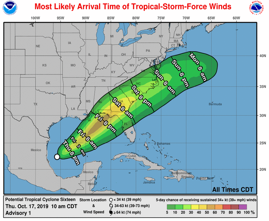
WIND:  Tropical storm conditions are expected to first reach the
coast within the warning area by late Friday, making outside
preparations difficult or dangerous.

RAINFALL: The disturbance is expected to produce total rainfall
accumulations of 2 to 4 inches this weekend from the central Gulf
Coast and northern and central Florida to the eastern Carolinas,
with isolated maximum amounts of 5 inches.


NEXT ADVISORY
-------------
Next intermediate advisory at 100 PM CDT.
Next complete advisory at 400 PM CDT.

$$
Forecaster Beven
Potential Tropical Cyclone Sixteen Discussion Number 1
NWS National Hurricane Center Miami FL AL162019
1000 AM CDT Thu Oct 17 2019
A complicated weather situation is evolving in the Gulf of Mexico.
The circulation associated with the tropical disturbance over the
southwestern Gulf of Mexico is getting better defined, and the
associated convection is getting better organized. However, a
strong mid- to upper-level trough is moving eastward across
southern Texas and northern Mexico, and a frontal system is present
over the northern and northwestern Gulf of Mexico. The ECMWF and
GFS models suggest that the trough will spawn a low along the
front, with the tropical disturbance merging with that low. On the
other hand, the UKMET suggests the tropical disturbance will become
the primary low pressure system. Either way, it is likely that a
low pressure area with gale-force winds and at least some tropical
cyclone characteristics will move northeastward and affect
portions of the northern Gulf coast during the next 36-48 h. Based
on this, advisories are initiated on Potential Tropical cyclone
Sixteen, and coastal tropical cyclone and storm surge
watches/warnings are being issued.
The system should track generally northeastward in the southern
portion of the mid-latitude westerlies, and the track model
guidance is in reasonably good agreement through 96 h. The forecast
track lies a little to the south of the model consensus, as the
UKMET has a somewhat more southerly track. The forecast track
brings the system across the southeastern United States between
48-72 h, and then has it moving into the Atlantic east of the
mid-Atlantic States.
Gradual strengthening is expected as strong upper-level
divergence caused by the trough partly prevails over strong
vertical shear. Thus, the intensity forecast calls for gradual
strengthening along the lines of that in the global models. It is
unlikely, though, that the system will develop into a classical
tropical cyclone. The system is expected to be fully extratropical
by 48 h, with gradual weakening expected after that time.
Regardless of the exact evolution of this weather system, portions
of the northern coast of the Gulf of Mexico will experience strong
winds, locally heavy rains, and storm surge Friday and Saturday.
Similar impacts are expected across portions of the Atlantic coast
of the southeastern United States Saturday and Sunday.
KEY MESSAGES:
1. Dangerous storm surge inundation of up to 5 feet above ground
level is possible along the Florida Gulf Coast from Indian Pass to
Clearwater, where a Storm Surge Watch is in effect. Residents in
these areas should follow advice given by local officials.
2. Tropical storm force winds are likely along portions of the
north-central and northeastern Gulf Coast where tropical storm
watches and warnings are in effect. Regardless of the exact track
and intensity of the system, these winds will cover a large area,
especially east of the center, and begin well in advance of the
arrival of the center.
3. Wind and coastal flooding hazards along the U.S. East Coast will
be covered by non-tropical watches and warnings issued by local NWS
offices, since the system is expected to lose any tropical
characteristics after it moves inland along the Gulf Coast.
FORECAST POSITIONS AND MAX WINDS
INIT 17/1500Z 22.4N 95.7W 30 KT 35 MPH…POTENTIAL TROP CYCLONE
12H 18/0000Z 23.7N 94.2W 35 KT 40 MPH…TROPICAL STORM
24H 18/1200Z 25.8N 91.0W 40 KT 45 MPH
36H 19/0000Z 28.5N 88.0W 45 KT 50 MPH
48H 19/1200Z 30.9N 85.0W 45 KT 50 MPH…POST-TROP/EXTRATROP
72H 20/1200Z 35.5N 77.2W 35 KT 40 MPH…POST-TROP/EXTRATROP
96H 21/1200Z 37.5N 70.0W 30 KT 35 MPH…POST-TROP/EXTRATROP
120H 22/1200Z 38.0N 66.5W 25 KT 30 MPH…POST-TROP/EXTRATROP
$$
Forecaster Beven


