Ida Expected To Be A Major Hurricane At Landfall Along Central Gulf Coast This Weekend
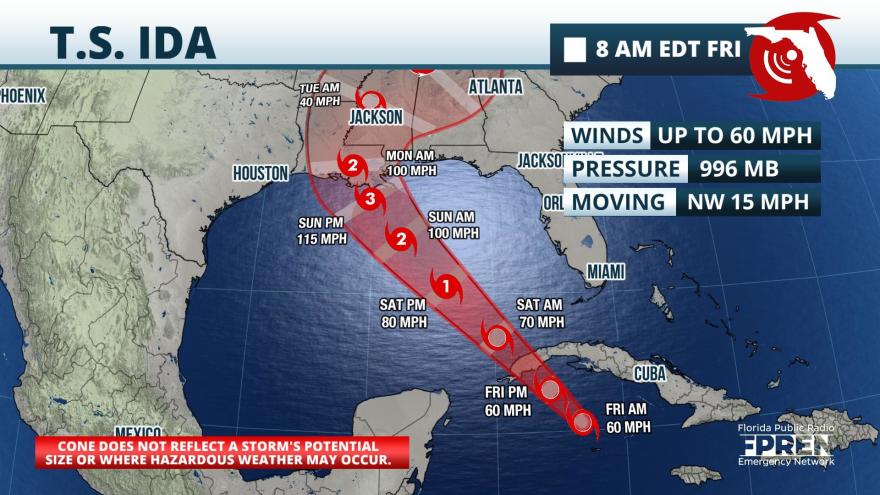
FPREN HQ – The season’s ninth named storm is likely to be a major hurricane before it makes landfall along the central Gulf coast sometime on Sunday.
Hurricane and Storm Surge Watches were issued late Thursday evening for most of the Louisiana and Mississippi Gulf coasts in anticipation of the possibility of hurricane-force winds and storm surges of 7 to 11 feet on Sunday. Tropical Storm Watches extended eastward along the Alabama coast, where outer rain bands have the potential of producing winds in excess of 40 mph.
As of Friday morning, Ida remained a tropical storm as it moved through the Cayman Islands. It is on track to move over to western Cuba Friday evening. Tropical Storm Warnings were in effect for these areas where tropical storm conditions and 8 to 12 inches of rain are expected Friday into Saturday. Isolated areas were expected to receive rainfall amounts as much as 20 inches.
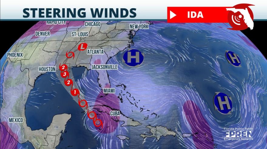
The wind flow steering Ida is well-defined. A large high-pressure ridge over the Carolinas will extend its influence into Florida over the weekend. The clockwise winds around this high will direct the storm toward the northwest in the direction of the Louisiana Gulf Coast. Almost all of the available global models and their respective ensembles forecast landfall in Louisiana, with much smaller chances that the center of Ida could pass over the upper Texas or Mississippi Gulf coasts.
Ida’s forecast path puts it on a track where it will pass over the deepest warm waters of the Gulf of Mexico. An upper-level low is causing some wind shear over Ida Friday morning, which tends to slow down a storm’s intensification. This low and the resulting wind shear is expected to weaken, resulting in warm water and a low wind shear environment in the Gulf of Mexico. These two factors strongly favor Ida’s rapid intensification after it moves into the Gulf and before landfall along the Gulf coast.
Here are the 5 AM EDT August 27th Key Messages for Tropical Storm #Ida. Significant intensification to a Major #Hurricane is now forecast in the Gulf of Mexico. Hurricane & Storm Surge Watches are in effect for parts of the LA, MS, and AL coast.
Latest: https://t.co/4LIsgbp8uT pic.twitter.com/0VdRURC6iO
— National Hurricane Center (@NHC_Atlantic) August 27, 2021
Tropical storm-force winds are most likely to arrive along the southeast coast of Louisiana, Mississippi, and potentially Alabama on Sunday morning. These winds make it harder for residents and visitors to execute their hurricane plans. Emergency officials and forecasters say those in the watch areas should make the necessary preparations Friday and Saturday, and heed any evacuation advice from local officials.
The worst of the weather is likely to arrive Sunday afternoon, Sunday evening, and into Monday morning over the Louisiana and Mississippi coasts. These areas are most likely to experience surges, hurricane-force winds, and the heaviest rain. Isolated tornadoes are also possible later Sunday into Monday.
8/27 11PM Update: Tropical Storm Ida is forecast to become a hurricane as it moves into the Gulf of Mexico this weekend, potentially reaching near/at major hurricane strength Sunday. Multiple impacts are possible across the northern Gulf Coast (1/3). #mobwx pic.twitter.com/5F4UpSWWj2
— NWS Mobile (@NWSMobile) August 27, 2021
Far outer rain bands may produce pockets of heavy rain and flash flooding as far east as the western Florida Panhandle Sunday into Monday. The largest hazards in the Panhandle are likely to be rip currents and minor coastal flooding near the times of high tide.
Story by FPREN Ray Hawthorne.


