Tropical Storm Zeta Forms. Risk to Northern Gulf Coast Increases
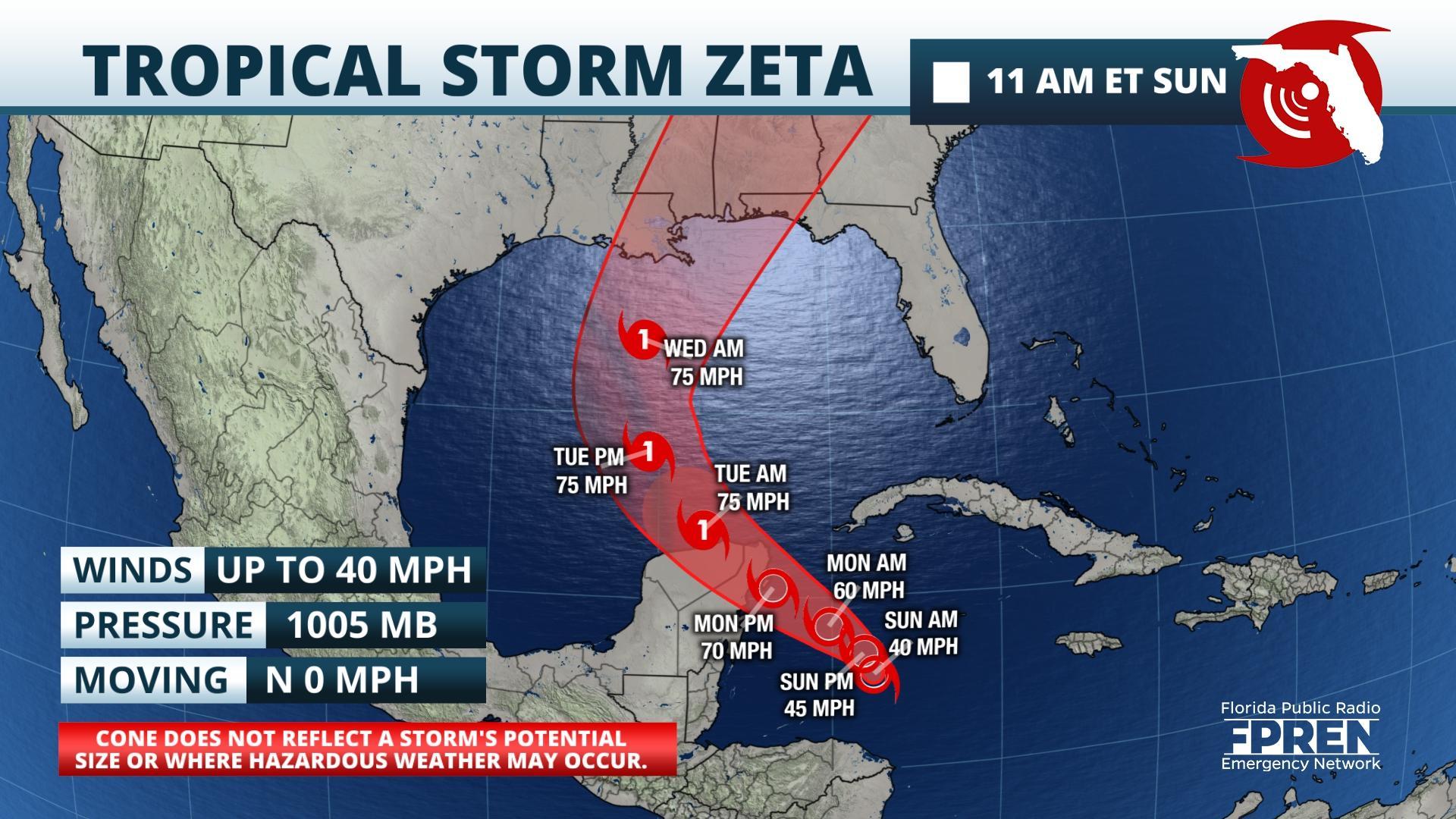
FPREN HQ – Tropical Storm Zeta formed early Sunday morning in the northwestern Caribbean, 400 miles to the south-southeast of western Cuba. While it is too soon to know if Zeta will pose a direct threat to the Sunshine State it is expected to continue to bring heavy rainfall and flooding to southern areas.
Torrential downpours and flash flooding will continue to be a threat through Sunday for most of South Florida and the western Bahamas. A Flood Watch remains in effect for parts of southeast Florida Sunday. Additional rainfall accumulations of three to six inches with isolated higher amounts possible. A few stronger thunderstorms could also produce localized damaging wind gusts and the chance of waterspouts. Zeta is expected to bring storm surge, flooding rains, and wind impacts to portions of the Gulf Coast as early as Tuesday.
Zeta is forecast to slowly drift northwestward Sunday and Monday and approach parts of the Yucatán Peninsula Monday afternoon. A Tropical Storm Warning is in effect for the province of Pinar del Rio in western Cuba. A Hurricane Watch and a Tropical Storm Warning are in place for the northern Yucatán Peninsula. Once Zeta emerges into the central Gulf of Mexico, Tuesday, meteorologists at the National Hurricane Center say it will enter into a favorable environment which could strengthen Zeta into a hurricane as it moves northward towards the northern Gulf Coast.
The northern Gulf of Mexico is anticipated to be less conducive for development with high vertical wind shear and cooler sea surface temperatures which should aid in weakening the system as it approaches the coast sometime Wednesday afternoon. However, the exact track and strength of Zeta remains speculative. There will still be a chance that Zeta impacts at hurricane-strength and all Gulf Coast residents should continue to monitor the progression of this storm over the coming days.
Louisiana in particular has experienced a turbulent hurricane season so far this year with four total tropical cyclones impacting the state. Tropical Storm Cristobal came ashore over southeastern Louisiana on June 7th, followed by Tropical Storm Marco on August 24th. Three days later, Hurricane Laura made landfall as a Category 4 near Cameron. Laura tied with the 1856 Last Island Hurricane as the strongest hurricane on record to make landfall in the state as measured by maximum sustained wind speeds. Finally, on October 9th, the state was impacted again, this time by Hurricane Delta, a Category 2 storm. If Hurricane Zeta comes ashore in Louisiana this week it will be the fifth tropical cyclone this year, and the eleventh cyclone to impact the continental United States, both of which are records.
Only one other storm in history has been named Zeta and that occurred in the 2005 Hurricane Season. Zeta (2005) was the second tropical system on record to cross into a new year forming on December 30, 2005 and dissipating on January 7, 2006. The names Eta, and every succeeding letter used from the Greek alphabet, have never been used.


