Potential Tropical Cyclone 26 Forming In The Central Caribbean
Gainesville, Florida – A broad area of showers and thunderstorms, referred to as Potential Tropical Cyclone 26 (PTC 26), is expected to enter the southern Gulf of Mexico by midweek bringing an increase in moisture to the Sunshine State and possibly threatening northern Gulf coastlines.
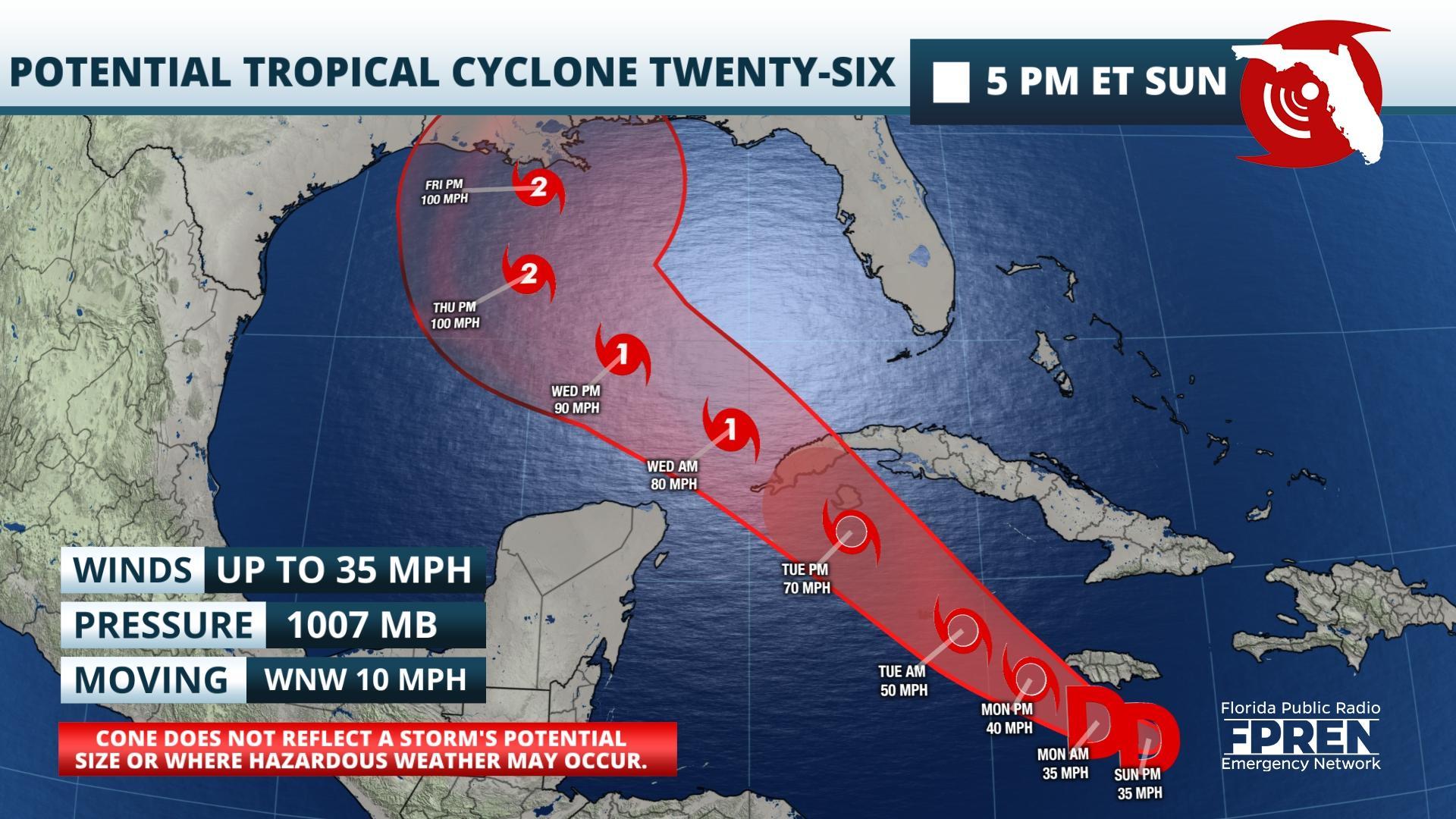
PTC 26 was designated by the National Hurricane Center Sunday afternoon 90 miles to the south of Kingston, Jamaica. Meteorologists anticipate that environmental conditions will become more favorable for further development and a tropical depression could form late Sunday night.
The Government of the Cayman Islands has issued a Tropical Storm Warning and the Cuban Government has issued a Hurricane Watch for the Isle of Youth and the provinces of Del Rio and Artemisa. A Tropical Storm Watch has been issued for the province of La Habana. Heavy rainfall is expected to affect portions of Hispaniola, Jamaica, the Cayman Islands, and western Cuba over the next few days and could lead to life-threatening flash floods and mudslides, according to the National Hurricane Center.
Weather models are in a general agreement that PTC 26 will continue tracking to the west-northwest across the Caribbean and travel between the Yucatán Peninsula and near western Cuba before entering into the Gulf of Mexico by Wednesday and possibly strengthening into a hurricane. Long-term model guidance begins to vary greatly regarding strength and direction once the system enters into the Gulf of Mexico.
Preliminary models are suggesting a high pressure ridge building over much of the Southeast United States this week which will help to divert the storm northward and keep its distance from the Sunshine State. However, other weather models are hinting at the ridge building further east which could bring the disturbance closer to the state, particularly the Florida Panhandle. Moisture is expected to increase across the Florida Peninsula regardless of PTC 26’s track this week. The northern Gulf of Mexico is anticipated to remain unfavorable regarding high vertical wind shear and cooler sea surface temperatures close to the northern Gulf shorelines. Strong vertical winds could shear the rain field of the system and drag the moisture eastward towards Florida beginning in South Florida as early as Tuesday and progressing northward into the Florida Panhandle by next weekend where a potential landfall could occur somewhere along the northern Gulf Coast.
The National Hurricane Center says that there is a risk of dangerous storm surge, wind, and rainfall hazards along the coast from Louisiana to the western Florida Panhandle ahead of PTC 26. Residents are advised to monitor the progress of the system over the next several days.
Regardless of development and track, Floridians should remain vigilant over the next few weeks as the hurricane season approaches the final stretch. There are two other areas in the open Atlantic which have low chances for development over the next several days but pose no threat to any land masses.
If PTC 26 attains tropical storm status it will be given the Greek alphabet name Delta. This name has only been used once before in 2005 when it formed on November 23.
Story by Dr. Athena Masson of FPREN.
NHC is issuing advisories on Potential Tropical Cyclone Twenty-Six, currently located near Jamaica. Here are the Key Messages. For more information, visit https://t.co/tW4KeGdBFb pic.twitter.com/S30gv3IybC
— National Hurricane Center (@NHC_Atlantic) October 4, 2020


