Two Tropical Depressions Form and Forecast to Strengthen
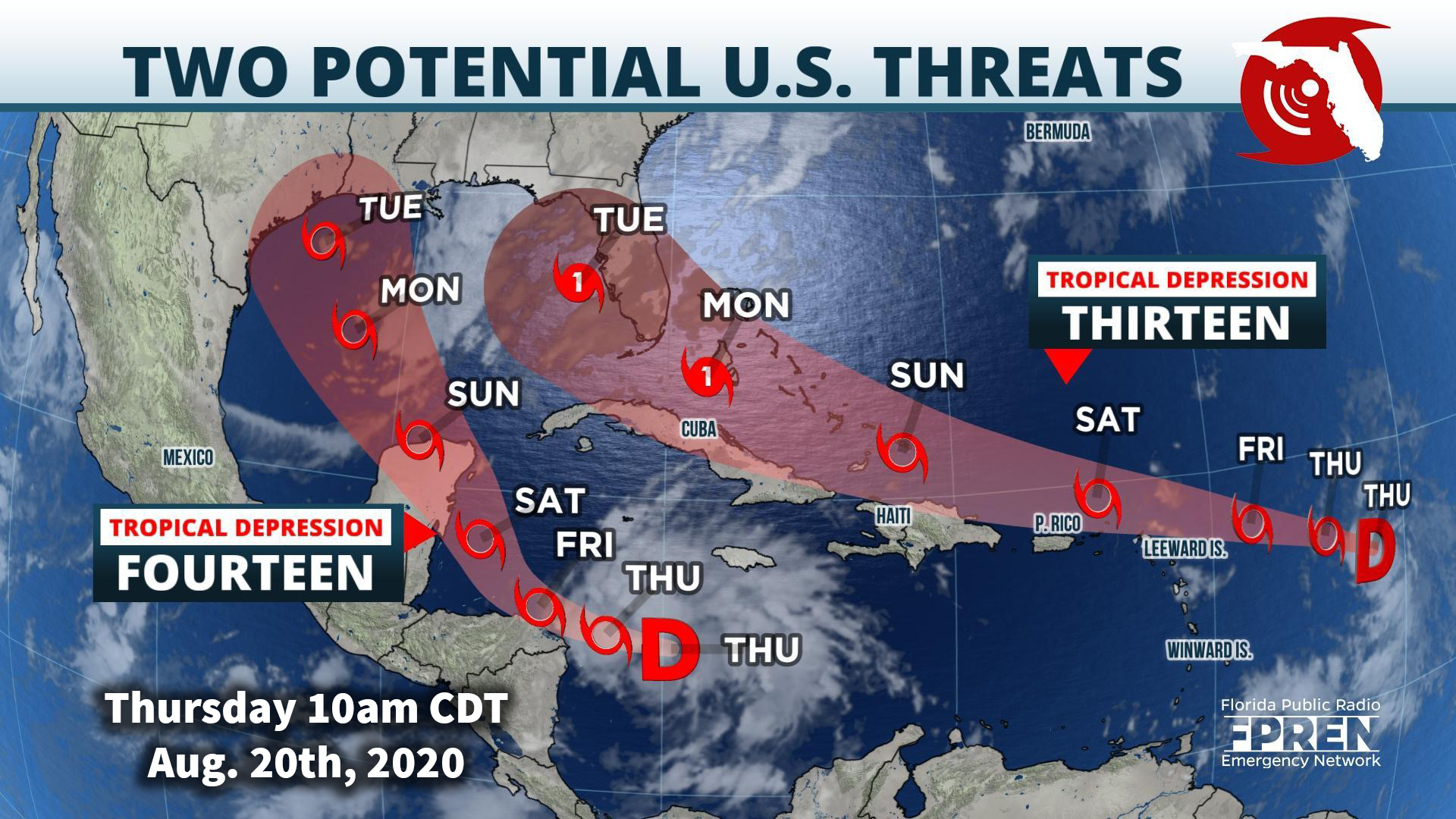
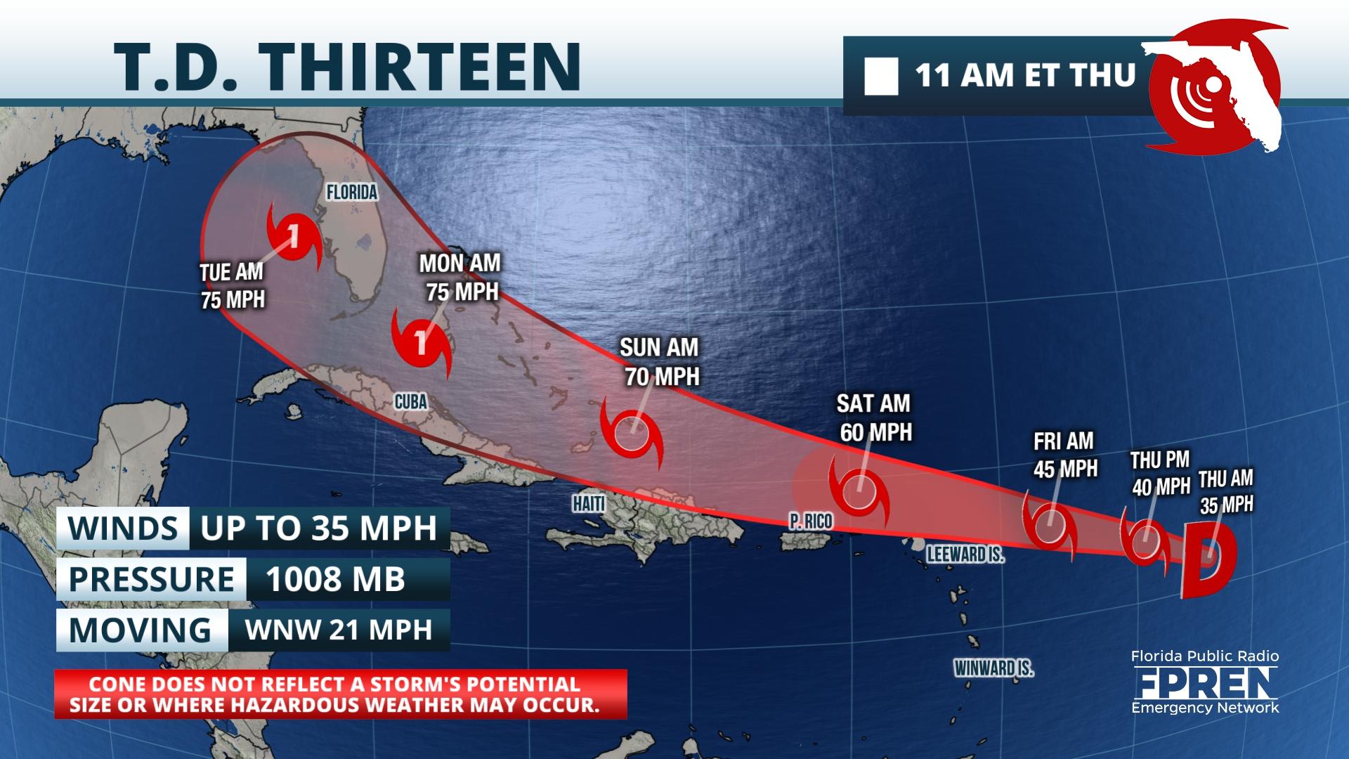
Gainesville, Florida – There have been few changes to Tropical Depression 13 since it formed last night. As of the midday Thursday advisory from the National Hurricane Center, it has top sustained winds of 35 mph and it is moving west-northwest at 21 mph. The depression is forecast to become a tropical storm later today. The latest National Hurricane Center forecast shows gradual intensification over the weekend as it passes near or north of Puerto Rico, Hispaniola, and Cuba. The forecast path and intensity calls for the system to be a hurricane somewhere near Cuba, Florida, or the eastern Gulf of Mexico Monday or Tuesday. However, there remains considerable uncertainty regarding the strength of the depression in a few days depending on how close it gets to the Caribbean islands.
A new Tropical Depression — Tropical Depression 14 — has formed in the central Caribbean Sea, about 235 miles east of the Nicaragua/Honduras border as of the 11 AM update from the National Hurricane Center. It has top sustained winds of 35 mph and it is moving toward the west near 21 mph. The depression is forecast to strengthen into a tropical storm later today or tonight. The forecast calls for the depression to be near hurricane strength as it approaches Mexico’s Yucatan Peninsula late Saturday. The latest forecast track takes the system toward the central or western Gulf of Mexico early next week.
The season’s thirteenth tropical depression formed late Wednesday evening and it is forecast to move near or just north of the Caribbean over the weekend. Meanwhile, a strong tropical wave south of Jamaica is showing signs of organization and it is likely to become a depression within a day or so.
As of mid-morning Thursday, the Hurricane Center said Tropical Depression 13 was moving west-northwestward near 21 mph with top sustained winds near 35 mph. The latest forecast calls for the depression to reach tropical storm status either late Thursday or early Friday, and then track near or just north of the northern Leeward Islands Friday evening. Additional strengthening is possible this weekend, but the Hurricane Center said nearby dry air and possible interaction with Puerto Rico, Hispaniola, or Cuba are factors causing the intensity forecast to be of low confidence.
The forecast track takes the system somewhere between Cuba, South Florida, and the eastern Gulf of Mexico Monday and Monday night as a strong tropical storm. Forecasters say there could be rainfall and wind impacts over these areas and interests in these areas should continue to monitor the system’s progress this weekend.
The strong tropical wave (called “97L” by meteorologists) is moving through the Caribbean this week and appears better organized on satellite imagery. The National Hurricane Center says it has a high chance of developing into a depression between now and the weekend as it moves toward the western Caribbean, Honduras, and Mexico’s Yucatan Peninsula. Forecast models have been inconsistent regarding the future path and strength of 97L. The models that forecast little or no development take 97L across the Yucatan or Central America, with some slow development over the western Gulf of Mexico next week. However, the models that show more rapid development forecast the developing system to move northward into the central Gulf of Mexico next week.
There have been few changes to Tropical Depression 13 since it formed last night. As of the midday Thursday advisory from the National Hurricane Center, it has top sustained winds of 35 mph and it is moving west-northwest at 21 mph. The depression is forecast to become a tropical storm later today. The latest National Hurricane Center forecast shows gradual intensification over the weekend as it passes near or north of Puerto Rico, Hispaniola, and Cuba. The forecast path and intensity calls for the system to be a hurricane somewhere near Cuba, Florida, or the eastern Gulf of Mexico Monday or Tuesday. However, there remains considerable uncertainty regarding the strength of the depression in a few days depending on how close it gets to the Caribbean islands.
Story be Meteorologist Ray Hawthorne of FPREN. WKGC is an FPREN station.


