


Tropical Depression Seven forms in western Gulf of Mexico
Tropical Depression Seven Advisory Number 2
NWS National Hurricane Center Miami FL AL072019
1000 AM CDT Tue Sep 03 2019
…DISTURBANCE BECOMES A TROPICAL DEPRESSION…
…EXPECTED TO STRENGTHEN TO A TROPICAL STORM BY WEDNESDAY…
SUMMARY OF 1000 AM CDT…1500 UTC…INFORMATION
———————————————–
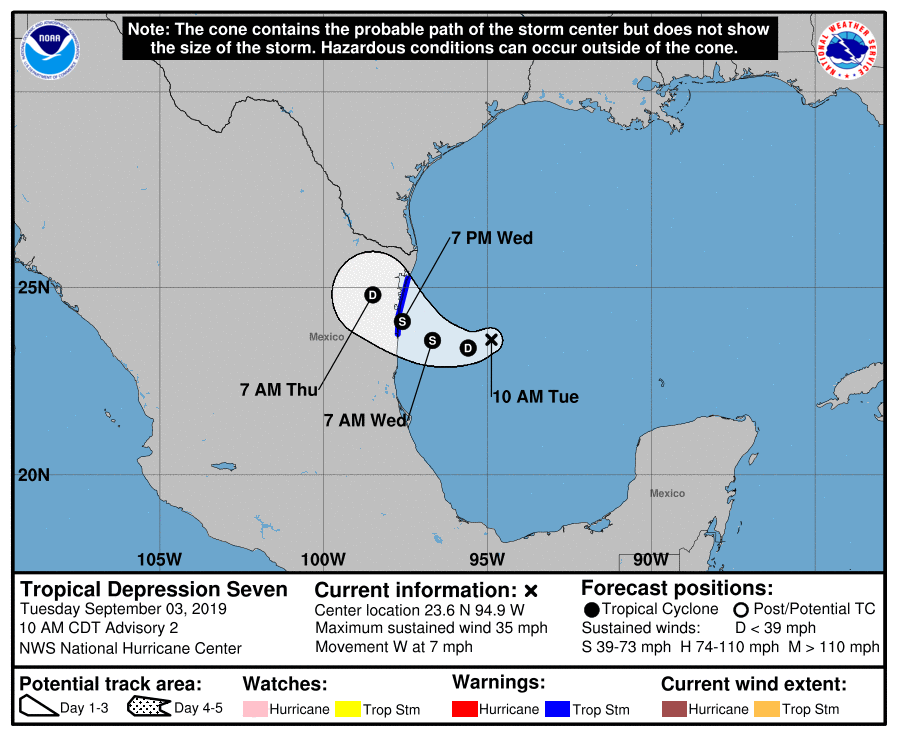
LOCATION…23.6N 94.9W
ABOUT 185 MI…295 KM E OF LA PESCA MEXICO
ABOUT 215 MI…345 KM ENE OF TAMPICO MEXICO
MAXIMUM SUSTAINED WINDS…35 MPH…55 KM/H
PRESENT MOVEMENT…W OR 260 DEGREES AT 7 MPH…11 KM/H
MINIMUM CENTRAL PRESSURE…1004 MB…29.65 INCHES
WATCHES AND WARNINGS
——————–
CHANGES WITH THIS ADVISORY:
None.
SUMMARY OF WATCHES AND WARNINGS IN EFFECT:
A Tropical Storm Warning is in effect for…
* La Pesca to Barra El Mezquital
A Tropical Storm Warning means that tropical storm conditions are
expected somewhere within the warning area within 36 hours.
Interests elsewhere along the northeastern coast of Mexico and the
lower Texas coast should monitor the progress of this system.
Additional watches or warnings could be required later today for
portions of these areas.
For storm information specific to your area, please monitor
products issued by your national meteorological service.
DISCUSSION AND OUTLOOK
———————-
At 1000 AM CDT (1500 UTC), the center of Tropical Depression Seven
was located near latitude 23.6 North, longitude 94.9 West. The
depression is moving toward the west near 7 mph (11 km/h), and this
motion is expected to continue today. A motion toward the west-
northwest is forecast tonight and Wednesday. This motion could
bring the system near or over the coast of northeastern Mexico late
Wednesday.
Maximum sustained winds are near 35 mph (55 km/h) with higher gusts.
Slow strengthening is forecast before the system moves inland, and
the depression is expected to become a tropical storm by Wednesday.
The estimated minimum central pressure is 1004 mb (29.65 inches).
HAZARDS AFFECTING LAND
———————-
WIND: Tropical storm conditions are expected to first reach the
coast within the warning area during the day Wednesday, making
outside preparations difficult or dangerous. Squalls with gusts to
tropical-storm force are likely north of the warning area along
portions of the northeastern coast of Mexico and the lower Texas
coast.
RAINFALL: The system is expected to produce the following
rainfall totals through Friday:
Northeast Mexico: 6 to 12 inches, isolated 15 inches, highest in the
Sierra Madre Oriental of Tamaulipas and Nuevo Leon. This rainfall
may cause life-threatening mudslides and flash floods.
South Texas and the Lower Texas Coast: 2 to 4 inches, isolated 6
inches.
NEXT ADVISORY
————-
Next intermediate advisory at 100 PM CDT.
Next complete advisory at 400 PM CDT.
$$
Forecaster Beven
Tropical Depression Seven Discussion Number 2
NWS National Hurricane Center Miami FL AL072019
1000 AM CDT Tue Sep 03 2019
First-light visible imagery indicates that the circulation of the
low pressure area in the western Gulf of Mexico has become better
defined, and that the system has sufficient organized convection to
be designated a tropical depression. The initial intensity of 30 kt
is based mainly on persistence from earlier scatterometer data.
The initial motion is 260/6. A deep-layer ridge over the southern
United States is expected to steer the cyclone generally westward
to west-northwestward through its lifetime. The new forecast track
is between the HCCA and the TVCA consensus models and calls for the
center to reach the northeastern coast of Mexico in about 36 h.
The new track is shifted a little to the north of the previous
track, but not significantly far enough to increase the threat to
south Texas.
Conditions appear conducive for gradual strengthening before the
cyclone moves into Mexico. However, the broad and large nature of
the circulation is likely to prevent rapid intensification before
landfall. The new intensity forecast is an update of the previous
forecast and calls for the system to become a tropical storm before
reaching Mexico, followed by dissipation over northeastern Mexico
by 72 h.
The primary threat from this system will be heavy rainfall that
could produce flooding and mudslides, especially in the mountainous
areas of Mexico.
FORECAST POSITIONS AND MAX WINDS
INIT 03/1500Z 23.6N 94.9W 30 KT 35 MPH
12H 04/0000Z 23.4N 95.6W 30 KT 35 MPH
24H 04/1200Z 23.6N 96.7W 35 KT 40 MPH
36H 05/0000Z 24.1N 97.6W 40 KT 45 MPH
48H 05/1200Z 24.8N 98.5W 30 KT 35 MPH…INLAND
72H 06/1200Z…DISSIPATED
$$
Forecaster Beven


