Major Hurricane Dorian Prompts Watches for parts of the East Coast
FPREN HQ – Tropical Storm Watches have been posted in advance of Hurricane Dorian, which is slowly moving closer to the state.
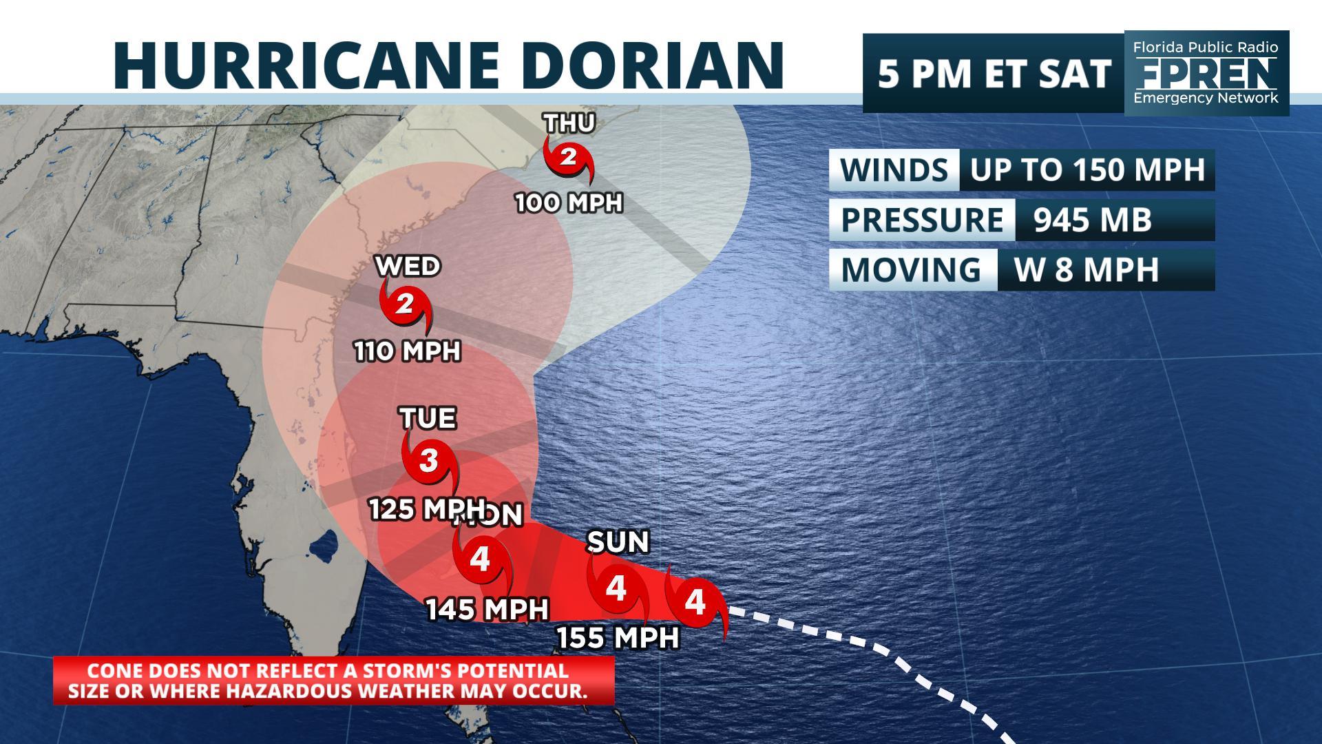
Dorian remains a powerful category 4 hurricane with top sustained winds of 150 mph as of the 5 pm Saturday update from the National Hurricane Center. Seasonably warm ocean temperatures and light wind shear — both of which are normally needed for intense hurricanes — are expected to fuel the storm for several more days.
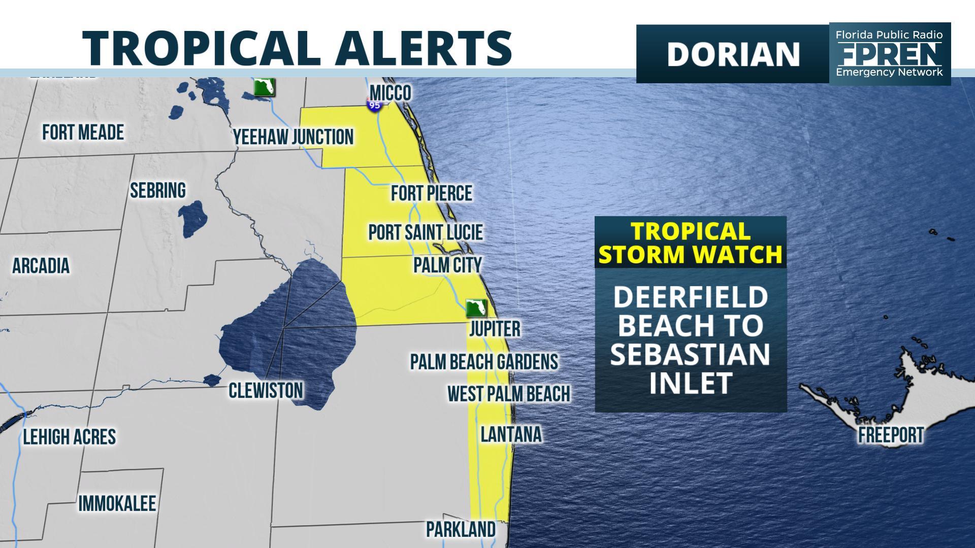
A significant change in the weather pattern that is steering Dorian is likely to keep the worst of the hurricane just offshore the Florida east coast. However, the hurricane is large enough and Dorian may come close enough to spread tropical storm force winds to portions of southeast and east-central Florida. Tropical storm force winds extend about 105 miles from the center, and National Hurricane Center forecasters say that could expand. For these reasons, the center issued Tropical Storm Watches from Deerfield Beach in Broward county to Sebastien Inlet near the Brevard/Indian River county line. High surf and rip currents are expected this weekend into early next week, regardless of the exact track of Dorian.
A ridge of high pressure that is steering the Dorian is forecast to keep pushing it westward this weekend toward the northwestern Bahamas. The ridge; however, is now forecast to be much weaker by Monday, which will cause it to slow or stall just offshore of Florida Monday. A turn toward the north is likely Tuesday and Wednesday, in the general direction of the Carolinas.
Tropical storm force winds are expected to reach parts of South Florida and the Space Coast on Monday, gradually spreading toward Daytona Beach and the First Coast on Tuesday. Hurricane force winds are becoming less likely and should stay offshore.
Coastal flooding is likely, regardless of how close Dorian gets to the state. The new moon is causing high astronomical tides during the times of high tide. The National Weather Service in Jacksonville has issued Coastal Flood Advisories. Tidal departures may reach 1 to 2 feet above normal this weekend.
NOAA’s Weather Prediction Center says 2 to 5 inches of rain may still fall along portions of the east coast, but these amounts may change depending on exactly how close the storm gets.
Story by FPREN Meteorologist Ray Hawthrone
National Hurricane Center
Hurricane Dorian Discussion Number 30
Hurricane Dorian Discussion Number 30
NWS National Hurricane Center Miami FL AL052019
500 PM EDT Sat Aug 31 2019
Dorian’s satellite presentation continues to be outstanding. The
eye has remained very distinct and is surrounded by a ring of very
deep convection. The latest information from the Air Force plane
before it departed Dorian supports keeping an initial intensity of
130 kt. Dorian is forecast to move over a deep layer of very warm
waters, and with the prevailing low shear along the hurricane’s
path, some additional strengthening is possible during the next day
or so. Most likely, however, the hurricane will experience some
fluctuations in intensity due to eyewall replacement cycles that are
difficult to predict. Beyond 3 days, as the hurricane begins to gain
latitude and encounters increasing shear, gradual weakening is
anticipated, but Dorian will remain a dangerous hurricane through 5
days.
The best estimate of the initial motion is toward the west or 280
degrees at 8 kt. The hurricane is being steered by the weak flow to
the south of the ridge of high pressure over the western Atlantic.
In about a day or two, most of the global models shift the high
eastward and deepen a trough over the eastern United States.
Consequently, the steering currents should collapse and Dorian
is anticipated to drift toward the northwest and north-northwest
while is moving over the northwestern Bahamas and near the east
coast of Florida. After that time, the hurricane should begin to
move a little faster northward as the trough over the eastern U.S
deepens and should then steer the hurricane toward the northeast by
the end of the forecast period.
The guidance has not changed significantly since the earlier run, so
it has not been necessary to adjust the NHC forecast in this
advisory. The uncertainty in the track is high while the hurricane
is moving slowly across the northwestern Bahamas and near the east
coast of Florida. Any deviation of Dorian’s core to the left would
result in an increase in the winds along the east coast of Florida.
Given that the area of tropical storm force winds could expand, and
taking into account the uncertainty in the track forecast, a
tropical storm watch was issued for the east of Florida from
Deerfield Beach to Sebastian Inlet.
Key Messages:
1. A prolonged period of life-threatening storm surge, devastating
hurricane-force winds, and heavy rains capable of life-threatening
flash floods are expected on the Abaco Islands and Grand Bahama
Sunday through Monday, and a hurricane warning is in effect for
these areas.
2. A tropical storm watch is in effect for a portion of the Florida
east coast. Since Dorian is forecast to slow down and turn northward
as it approaches the coast, life-threatening storm surge and
dangerous hurricane-force winds are still possible along portions of
the Florida east coast by the early to middle part of next week.
Residents should have their hurricane plan in place, know if they
are in a hurricane evacuation zone, and listen to advice given by
local emergency officials.
3. There is an increasing risk of strong winds and dangerous storm
surge along the coasts of Georgia, South Carolina, and North
Carolina during the middle of next week. Residents in these areas
should continue to monitor the progress of Dorian.
4. Heavy rains, capable of life-threatening flash floods, are
possible over coastal sections of the southeastern United States
from Sunday through much of next week.
FORECAST POSITIONS AND MAX WINDS
INIT 31/2100Z 26.2N 74.4W 130 KT 150 MPH
12H 01/0600Z 26.4N 75.7W 135 KT 155 MPH
24H 01/1800Z 26.6N 77.0W 130 KT 150 MPH
36H 02/0600Z 26.8N 78.0W 125 KT 145 MPH
48H 02/1800Z 27.2N 78.5W 120 KT 140 MPH
72H 03/1800Z 28.3N 79.1W 110 KT 125 MPH
96H 04/1800Z 31.0N 80.0W 95 KT 110 MPH
120H 05/1800Z 34.0N 77.0W 85 KT 100 MPH
$$
Forecaster Avila/Brennan


