Tropics are heating up in the Atlantic
National Hurricane Center
Special Tropical Weather Outlook
Special Tropical Weather Outlook
NWS National Hurricane Center Miami FL
1120 AM EDT Sat Aug 24 2019
For the North Atlantic…Caribbean Sea and the Gulf of Mexico:
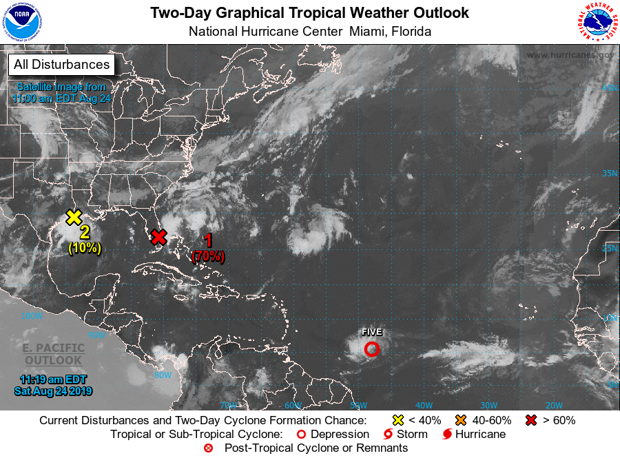
Special Tropical Weather Outlook issued to discuss the low pressure
area in the northwestern Gulf of Mexico, the formation of Tropical
Depression Five, and the aircraft for the Florida low.
The National Hurricane Center is issuing advisories on newly-formed
Tropical Depression Five, located about 800 miles east-southeast of
Barbados.
1. A broad area of low pressure located inland over South Florida
is producing a large area of disorganized showers and thunderstorms
that extends eastward over the northwestern Bahamas and the adjacent
Atlantic waters. Significant development of the low is unlikely
today while it drifts northward over the southern or central Florida
peninsula. However, environmental conditions appear conducive for
gradual development once the low moves off the east-central coast of
Florida over the western Atlantic by Sunday, and a tropical or
subtropical depression is likely to form early next week while the
system moves northeastward offshore of the southeastern United
States coast.
Regardless of development, locally heavy rains are possible over the
northwestern Bahamas and the southern and central Florida peninsula
through the weekend. Interests in the northwestern Bahamas, the
Florida peninsula, and the southeastern coast of the United States
should monitor the progress of this system. The Air Force Reserve
Hurricane Hunter aircraft scheduled to investigate the system this
afternoon has been canceled. Another aircraft is scheduled to
investigate the system on Sunday.
* Formation chance through 48 hours…high…70 percent.
* Formation chance through 5 days…high…90 percent.
2. Surface observations and satellite imagery indicate that a low
pressure area has formed just off the upper Texas and southwestern
Louisiana coasts. The associated shower and thunderstorm activity
shows signs of organization. However, the system is likely to move
inland over eastern Texas and western Louisiana before significant
development can occur. Regardless of development, this system is
expected to bring locally heavy rains to portions of Louisiana and
eastern Texas during the next day or two.
* Formation chance through 48 hours…low…10 percent.
* Formation chance through 5 days…low…10 percent.
Public Advisories on Tropical Depression Five are issued under WMO
header WTNT35 KNHC and under AWIPS header MIATCPAT5.
Forecast/Advisories on Tropical Depression Five are issued under WMO
header WTNT25 KNHC and under AWIPS header MIATCMAT5.
Forecaster Beven
A new tropical depression formed over 2000 miles away from the United States Saturday, and it’s likely to be of more interest to Floridians than one forming in their own backyard.
The National Hurricane Center began advisories on Tropical Depression Five at 11 am Saturday, which was located 805 miles east-southeast of Barbados and moving west at 12 mph. The latest information direct from the National Hurricane Center is available in this story below.
Tropical Depression Five forms in Atlantic
Forecasters at the National Hurricane Center have encouraged residents of the central and northern Lesser Antilles to closely monitor this system, as it could intensify into a hurricane by the time it passes through the island chain. Tropical Depression Five is no immediate threat to Florida, but long range forecast data suggests it could move in the general direction of the northern Caribbean or southeastern United States in about a week. It is far too soon to credibly predict how strong it may be at that time or where specifically it would track.
Meanwhile in Florida
Meanwhile in South Florida, a small swirl of a low pressure system was producing an area of disorganized showers from Miami to West Palm Beach Saturday morning. Forecasters at the National Hurricane Center still expect this system (referred to as Invest 98) to become a tropical depression or storm in the next 48 hours, but it does not pose a significant tropical threat to the state.

A tropical depression or storm is most likely to form from Invest 98 when it moves back over the warm nearshore waters of the Atlantic Ocean. Regardless of its tropical status, the presence of tropical moisture is likely to produce periods of heavy rain and stronger thunderstorm activity at times through Sunday, especially in areas near and east of I-95 from Melbourne to Miami.
Choppy seas and a high risk of rip currents are also in the forecast at most Atlantic Coast beaches this weekend. Local authorities and forecasters at the National Weather Service are urging all water enthusiasts, especially beach-goers and inexperienced swimmers, to use caution when entering the water. Conditions are forecast to gradually return to normal as the system pulls away early next week.


